

Chapter 3 – NOAA Operations – Satellite Management
| NOAA Continuously Monitors |
|---|
|
»Atmosphere »Oceans »Space »Land |
National Environmental Satellite, Data, and Information Service (NESDIS) is dedicated to providing timely access to global environmental data from satellites and other sources to promote, protect, and enhance the Nation’s economy, security, environment, and quality of life. To fulfill its responsibilities, NESDIS acquires and manages the Nation’s operational environmental satellites, operates the NOAA National Data Centers, provides data and information services including Earth system monitoring, performs official assessments of the environment, and conducts related research.
NESDIS‘ vision is to be the world’s most comprehensive source and recognized authority for operational satellite products, environmental information, and official assessments of the environment in support of societal and economic decisions. To achieve this vision, NESDIS collaborates with other agencies and organizations to describe changes to our climate and the implications of those changes. NESDIS works with other agencies and countries in establishing a global observing system to meet the world’s information needs for weather, climate, oceans, and disasters and developing a skilled, energetic, and dedicated workforce through training, motivation, and teamwork.
NOAA maintains two primary constellations of environmental satellites: polar-orbiting and geostationary satellites. These are part of NOAA’s integrated observing system, which includes satellites, radars, surface automated weather stations, weather balloons, sounders, buoys, instrumented aircraft and ships, and other sensors, along with the data management infrastructure needed for this system. This integrated system is the foundation upon which NOAA works towards achieving our four main goals—a weather-ready Nation, climate adaptation and mitigation, healthy oceans, and resilient coastal communities and ecosystems.
In addition to the legacy Geostationary and Polar-orbiting Programs, the NOAA Satellite Program portfolio also includes the Radar Altimetry and Solar Winds Programs.
 Figure 3-4 Field of view for the GOES constellation
The Geostationary Orbiting Environmental Satellite (GOES) Series Program has existed since 1974 and, due to its geosynchronous orbit, provides continuous hemispheric coverage from the West and East constellation. Continuous monitoring of severe storms and retrieval of atmospheric moisture gradients, currents flow dynamics, and atmospheric chemicals can only be effectively achieved without increased error rate and/or lost data segments from a stationary orbit, such as GOES’ geostationary orbit. These products support weather forecasting and various other applications, making the data provided by GOES very important to the Nation.
The GOES-13, -14 (back-up) and -15 are the current on-orbit operational assets, with GOES-13 and -15 positioned in the East and West, respectively. The next-generation follow-on series which is currently under development, GOES-R, is a major system upgrade with an initial launch capability in late 2015. Additional information about the GOES and GOES-R Programs can be found at www.ospo.noaa.gov/Operations/GOES/index.html, www.osd.noaa.gov/GOES_Overview, & www.goes.noaa.gov, and www.goes-r.gov
The Polar Orbiting Environmental Satellite (POES) Series Program has existed since the early 1960s with the launch of the first Television Infrared Observation Satellites (TIROS). NOAA’s POES satellites operate as part of a three satellite system constellation consisting of a Defense Meteorological Satellite Program (DMSP) satellite, a European Organization for the Exploitation of Meteorological Satellites (EUMETSAT) satellite, and a POES satellite flying in complementary orbits.

|
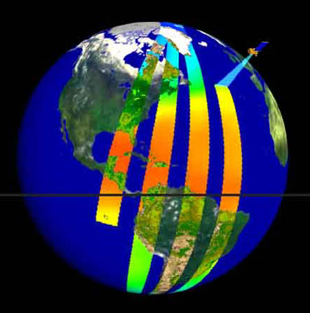 Figure 3-5 Ground track of POES Figure 3-5 Ground track of POES |
Figure 3.6 depicts the polar constellation fly-out chart. Because of the polar orbiting nature of the POES series satellites, these satellites are able to collect global data on a daily basis for a variety of land, ocean, and atmospheric applications. Data from the POES series supports a broad range of environmental monitoring applications including weather analysis and forecasting, climate research and prediction, global sea surface temperature measurements, atmospheric soundings of temperature and humidity, ocean dynamics research, volcanic eruption monitoring, forest fire detection, global vegetation analysis, search and rescue, and many other applications. More information about POES is available at www.ospo.noaa.gov/Operations/POES/index.html, & www.osd.noaa.gov/POES_Overview.
On October 28, 2011, the Suomi National Polar-orbiting Partnership (Suomi NPP) satellite successfully launched from the Vandenberg Air Force Base in California. The NPP includes a suite of upgraded imaging and sounding sensors. Within seven months after launch, the Suomi NPP data was being used in NOAA’s operational long range weather forecasts. Suomi NPP is the first satellite mission to address the challenge of acquiring a wide range of land, ocean, and atmospheric measurements for Earth system science while simultaneously preparing to address operational requirements for long range weather forecasting.
 Figure 3-6 Polar Constellation Fly-Out Chart
Suomi NPP has enabled NOAA to continue issuing accurate forecasts and provide advance warning for severe weather, such as deadly tornado outbreaks, blistering heat waves, floods, snowfall, and wildfires. During the past year, Suomi NPP data have been used to generate dozens of products and have been demonstrated with key users from across NOAA for the detection and monitoring of fire and smoke, clouds, fog, dust, snow and ice, precipitation, ocean color (chlorophyll for harmful algal blooms and ocean nutrients), sea surface temperature, vegetation cover, and the ozone hole. More information about Suomi NPP is available at www.nesdis.noaa.gov/npp_launch.html, www.npp.gsfc.nasa.gov/mission_details.html, & www.jpss.noaa.gov/instruments_interactive.html.
The Joint Polar Satellite System (JPSS) series is our Nation’s next generation polar-orbiting operational environmental satellite system. The JPSS, which includes an identical suite of upgraded imaging and sounding sensors manifested on S-NPP, is currently under development with an initial launch capability in 2017. Additional information about the JPSS Program is available at www.jpss.noaa.gov, & www.jpss.noaa.gov/satellites.html.
 Figure 3-7 How Radar Altimetry Works
The Radar Altimetry Program includes the on-orbit Jason-2 and the Jason-3 missions. Jason-3 is currently under development with a launch readiness date of no earlier than 2015. These missions are being implemented through international cooperative arrangements. Satellite radar altimetry provides sea level for determining ocean circulation, climate change and sea-level rise. Jason-2, launched on June 20, 2008, is the follow-on to the TOPEX/Poseidon and Jason-1 satellites. The Jason-2 is instrumental in meeting NOAA’s operational needs for sea surface height, wave height, and wind speed measurements necessary for ocean modeling, forecasting El Niño / La Niña events, and hurricane intensity prediction. The mission partners in addition to NOAA are NASA, France’s Centre National d’Etudes Spatiales (CNES), and the European Organisation for the Exploitation of Meteorological Satellites (EUMETSAT). More information about the international altimetry program can be found at: www.nasa.gov/mission_pages/ostm/main/index.html, www.eumetsat.int/Home/Main/Satellites/Jason-2/index.htm and www.sealevel.jpl.nasa.gov/missions/jason3.
The Deep Space Climate Observatory (DSCOVR) Program (solar winds mission) is a NOAA Earth observation and solar weather satellite currently under development with a launch readiness date of no earlier than late 2014. DSCOVR will be positioned at the Sun-Earth (L1) Lagrangian point, at a distance of 1.5 million kilometers from Earth.

|

|

|
The science objective of the mission is to continue solar wind measurements currently being provided by NASA’s Advanced Composition Explorer (ACE) mission. More information on the (DSCOVR) Project can be found at: www.wmo-sat.info/oscar/satelliteprogrammes/view/212, Deep_Space_Climate_Observatory _(DSCOVR)_Mission_Briefing.pdf, & www-pm.larc.nasa.gov/triana.html
NOAA satellites play a key role in supporting the forecasting of major weather and climate events that impact our Nation — from the searing heat waves, wildfires and drought, to Superstorm Sandy. Also, through the international Search and Rescue Satellite Aided Tracking (SARSAT) program, NOAA satellites were prominent in saving 263 people in the U.S. from life-threatening situations in 2012.

|

|

|
NOAA satellite data not only are the backbone of weather forecasts, they help drive NOAA’s efforts in coral reef preservation, identifying marine habitats, monitoring sea level rise, and improving bathymetric mapping. Across the globe, coastal-zone managers are seeking to understand coastal areas’ increasing vulnerability of rising sea levels and how to mitigate the consequences of inundation. Satellite-derived tools and methodologies help guide investments, and support decision-makers, locally, and globally in addressing and preparing for weather anomalies.
Additional information on NESDIS Programs and Offices may be found by going to: www.nesdis.noaa.gov.
")
